

May 14th marks the 215th anniversary of the start of the Lewis and Clark expedition. The Corps of Discovery, as the group was known, set out on an ambitious quest to traverse the North American continent. The trip is an invaluable window into American history, but also a source of scientific and cultural knowledge. To commemorate the beginning of the years-long journey, we’re following in the footsteps of Lewis and Clark with a decidedly 21st-century tool: Google Earth.
Editor’s note: Random-Access Memories is a new periodic series highlighting the ways in which major historical events have influenced ed tech. Got an idea for a future edition of R-AM? Drop us a line.
It was a rainy, windy day when the group of about 40 men set out from a camp on the Missouri River. Lead by Captain Meriwether Lewis and Lieutenant William Clark, they embarked on a heretofore impossible journey: to cross the Louisiana Territory, newly acquired by President Thomas Jefferson, and to catalog its species of flora, fauna, rivers, mountains, and people. They also endeavored to find a route to the edge of America, the Pacific Ocean. It was May 14, 1804. At the beginning of his soon-to-be copious notes, Clark scratched a simple update: “men in high Spirits.”
 While the historical importance of the group was well-known by the early 20th century, recent ed tech innovations allow educators of all types to lead their students down the trail forged by the legendary group. Along the way, the duo’s cultural, scientific, and cartographic observations are still of use to all kinds of educators today.
The best way to learn about the unprecedented three-year trip? Check the map, of course.
For Viewers Like You
Google Earth is a powerful tool. It lets users zoom, pinch, and drag their way to just about any patch of the planet, all thanks to satellite imagery. You can view things from above in two dimensions or click the 3D button to change your angle.
For more advanced maps, Google Education launched Voyager, a digital exhibition that uses Google Earth, with interactive routes, embedded video and text, and an easy click-through functionality. The Voyager application for Google Earth allows a map to go from static object to interactive storytelling tool.
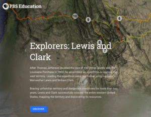
PBS Education took advantage of these features to create Explorers: Lewis and Clark. Designed for students in grades 3–7, this interactive map charts both the outbound and return trips, with stops along the way where students can zoom in, look at historic sites with Google’s famous Street View, read background information, and even watch videos custom-made for the project.
Tools for Digital Trailblazing


Here are a few of the powerful features included:
- Slideshow: The second stop, in Floyd’s Bluff, Iowa, includes a slideshow of contemporary and historical maps and a photo of the site today.
- 3D view: Want to get a closer look? 3D view shows topography and landscape, letting learners change the camera angle, switch direction, and get a sense of scale.
- Street View and Photo Sphere: Both functions let you jump down to ground level for a close-up view.
- YouTube videos: At some stops, custom YouTube videos give greater context.
- Descriptive sidebar: The map’s sidebar includes detailed descriptions of each stop; no switching windows or switching between a handout and a screen needed.
Mapping the Past, Present, and Future
 Google’s Voyager application isn’t limited to historical routes. Here are a few other interactive Google Earth maps you might be interested in.
- The Smithsonian Institution’s 10,000 Year of Volcanoes
- The Freedom Rides from the History Channel
- The Hidden Worlds of the National Parks uses immersive video and sounds to explore remote regions.
- Voyager also includes a number of games, including some based on everyone’s favorite red-hat-wearing geographic thief.
Discover More Resources
Looking for more resources on the Corps of Discovery? Or just want to get inspired by more interactive maps? Check the Lewis and Clark resources, maps, and lesson plans below.
- An interactive exhibit (and map) from the Gilder Lehrman Institute of American History.
- Connect with primary sources from the University of Nebraska and their digital version of the journals of the Lewis and Clark expedition.
- Check out this extensive, high school-level activity from the National Archives’ DOCSTeach page.
- Monticello, Thomas Jefferson’s plantation-turned-museum has a wealth of resources, activities, articles, and lesson plans in the Monticello Digital Classroom.
- Scholastic provides a collection of Lewis and Clark activities for grades 3–8.
- PBS also has a number of resources about the journey organized by subject, including science, math, and language arts, in addition to social studies.
- The National Education Association also has digital lesson plans about the expedition, for grades 4–12.
“louisville30”by myspomer is licensed under CC BY-NC 2.0![]()
![]()
![]()